


-
102 TAILWINDS DR BUENA VISTA, CO 81211
- Vacant Land / Resale (MLS)


Property Details for 102 TAILWINDS DR, BUENA VISTA, CO 81211
Facts
- Property ID: 819909105
- MLS Number: 7981444
- Parcel Number: R327121300008
- Property Type: Vacant Land
- County: Chaffee
- Listing Status: Active
Sale Type
This is an MLS listing, meaning the property is represented by a real estate broker, who has contracted with the home owner to sell the home.
Description
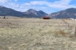
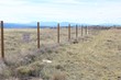
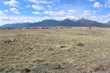
This listing is NOT a foreclosure. This 23-acre parcel is ideal for the buyer who needs access to an airport or who serves the aviation sector, as it shares a fence with the Central Colorado Regional Airport (CCRA). The seller owns a Through the Fence Agreement (TTF) which will be included with the purchase of the land. The opening for the TTF straddles this parcel and the parcel to the north. A shared easement can be in place to insure both parcels have suitable access to the opening. Access to the property is from CR 319, just past the airport office and hangars, approximately one mile south of Buena Vista. Zoned by Chaffee County as Industrial. Signature views of the Collegiate Range with 3 of the 4 peaks being visible. Utilities (public water and sewer, 3ph power, and fiber optic cable) are nearby and will be the responsibility of the buyer. If buyer prefers, the parcel is eligible for a well and septic rather than the public utilities. Single phase power is at the entrance to the parcel on CR 319. And very good high-speed Internet is available via clear wireless signal. A unique property with airport access -- the most centrally located airport to four of Colorados major ski areas Monarch, Breckenridge, Copper Mountain, and Ski Cooper, VFR on most days, and an 8,300 ft. runway, with reasonably priced airport services. CCRA is located at an elevation of 7950.4 ft. and boasts the longest high-altitude runway in Colorado at 8,300, along with a full-length taxiway. CCRAs identifier is AEJ (KAEJ). General flight information and supplemental resources can be found on the AirNav website. AWOS and weather data analysis is available, as is ARNAV (GPS) approach. CCRA sits on a mesa above the intersection of US 285 and US 24. Throughout most of the year, the sky above the airport is cloudless, even though the surrounding mountains may be shrouded by clouds. Consequently, the airport enjoys many more days of visibility than most mountain airfields. Immediate possession upon transfer of funds.
Real Estate Professional In Your Area
Are you a Real Estate Agent?
Get Premium leads by becoming a RealtyStore.com preferred agent for listings in your area
Click here to view more details
Property Brokerage:
Century 21 Summit Realty, Inc
602 Hwy 24 South
Buena Vista
CO
81211
Copyright © 2024 ROCC/REcolorado. All rights reserved. All information provided by the listing agent/broker is deemed reliable but is not guaranteed and should be independently verified.

All information provided is deemed reliable, but is not guaranteed and should be independently verified.